Installation#
Note
Dependencies: QGIS and GDAL must be installed on your system before using the deforisk plugin. On Unix-like systems, you must also install osmconvert and osmfilter. On Windows systems, these dependencies are already included in the plugin as binary .exe files so you don’t need to install them. Then, the forestatrisk and riskmapjnr Python packages must be installed on your system. Follow the instructions below to install these dependencies.
Note
Installation: We hereby describe two ways for installing the deforisk plugin:
First option is to install the QGIS client and GDAL on your system and then install the
forestatriskandriskmapjnrPython packages. This installation procedure is system-dependent.Alternative option is to use conda/mamba (one of those two) to install QGIS, GDAL,
forestatriskandriskmapjnrin a dedicated environment. This installation procedure is system-independent.
On Windows#
Turn on the developer mode (recommended)#
The developer mode on Windows allows creating symbolic links (symlinks) which are used by the plugin and useful to avoid copying large files on disk. To activate the developer mode, follow these instructions. In summary:
Enter “for developers” into the search box in the taskbar to go to the “For developers” settings page.
Toggle the Developer Mode setting, at the top of the “For developers” page.
Read the disclaimer for the setting you choose. Click “Yes” to accept the change.
Enabling Developer mode requires administrator access. If your device is owned by an organization, this option may be disabled. If the developer mode is no activated on Windows, it does not prevent the use of the deforisk plugin. But large files will be copied in several directories and will occupy a large space on disk.
Install QGIS and GDAL on Windows#
To install QGIS and GDAL on Windows, use the OSGeo4W network installer. OSGeo4W is a binary distribution of a broad set of open source geospatial software for Windows environments (Windows 11 down to 7). Select Express Install and install both QGIS and GDAL. Several Gb of space will be needed on disk to install these programs. This will also install OSGeo4W Shell to execute command lines.
Install the forestatrisk and riskmapjnr Python packages on Windows#
To install the forestatrisk and riskmapjnr Python packages, open OSGeo4W Shell, and use pip.
python3.exe -m pip install --upgrade forestatrisk riskmapjnr
Note: In case of problems, you can check the version of Python used by OSGeo4W using OSGeo Shell and that the package wheels for forestatrisk and riskmapjnr are available on PyPI for your Windows and Python versions. Currently, PyPI provides wheels for Python >= 3.9 for Windows, Linux, and macOS 64-bit systems.
python3.exe --version
On Unix-like systems (Linux and macOS)#
Install QGIS and GDAL on Unix-like systems#
Install QGIS and GDAL on your system, for example using apt-get for Debian/Ubuntu Linux distributions.
sudo apt-get update
sudo apt-get install qgis gdal-bin libgdal-dev
For macOS, you can use the installer available on the QGIS website and install GDAL using brew.
After installing GDAL, you can test the installation by running gdalinfo --version in the command prompt or terminal, which should display the installed GDAL version.
Install osmconvert and osmfilter#
On Unix-like systems, you must also install osmconvert and osmfilter before using the deforisk plugin. osmconvert can be used to convert and process OpenStreetMap files while osmfilter is a command line tool used to filter OpenStreetMap data files for specific tags. To install them on your system, follow the instructions on the osmconvert and osmfilter webpages.
Install the forestatrisk and riskmapjnr Python packages on Unix-like systems#
On recent systems, you cannot use pip to install Python packages system-wide. As a consequence, we need to create a virtual environment and install the forestatrisk and riskmapjnr packages in it. Make sure to also install the appropriate GDAL bindings using gdal==$(gdal-config --version). Once the package and its dependencies have been installed, you can deactivate the virtual environment.
python3 -m venv /path/to/venv
source  /path/to/venv/bin/activate
python3 -m pip install --upgrade forestatrisk riskmapjnr gdal==$(gdal-config --version)
deactivate
Then, in the startup.py Python file, add the following two lines, adapting the path to your specific case (check the Python version). These two lines will be executed when QGIS starts and will add the path to the packages installed in the virtual environment to sys.path.
import sys
sys.path.append("/path/to/venv/lib/python3.11/site-packages/")
Using miniforge (all operating systems)#
This alternative method has the advantage of installing QGIS and GDAL as well as the forestatrisk and riskmapjnr Python packages all in a isolated and dedicated environment, with a lightweight version of QGIS. However, caveats are that there are no QGIS desktop icons or file association, and this installation does not include GRASS and SAGA for example (although they can easily be installed with conda/mamba afterwards).
Install miniforge#
Miniforge provides access to conda and mamba which are two package and environment managers. Miniforge is preconfigured to use the conda-forge channel to download packages. To install miniforge, download the installer from the miniforge webpage and follow the instructions for your operating system.
Install QGIS and dependencies in a new environment#
In a terminal, create a new environment (here named deforisk) and install QGIS (using conda-forge packages), forestatrisk and riskmapjnr in this environment. Be aware that osmconvert and osmfilter still need to be installed separately on Linux and macOS systems (cf. section above).
mamba create -n deforisk qgis=3.38.2           # create environment and install QGIS (and GDAL embedded)
mamba activate deforisk                        # activate the newly created environment
pip install --upgrade forestatrisk riskmapjnr  # install additional Python packages
You can now launch QGIS from the terminal using the qgis command.
Deactivate and delete the environment#
I you want to deactivate an delete the environment:
mamba deactivate
mamba env remove --name deforisk
Access to GEE and WDPA#
The plugin download forest data from Google Earth Engine (GEE) using the geefcc Python package and protected area data from the World Database on Protected Areas (WDPA) using the pywdpa Python package. You will need an access to GEE and WDPA to be able to use the plugin.
Access to GEE#
To be able to use GEE, you will need either (i) a Google account and a Google Cloud project that is registered to use Earth Engine or (ii) a service account allowing you to use Google Earth Engine through a registered Google Cloud project (in this case, you don’t need a Google account). Please follow this link if you want to register a project for using Earth Engine.
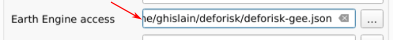
In the deforisk plugin, for the Earth Engine access argument available in the “Get variables” tab, you must indicate either the name of a Google Cloud project registered to use Earth Engine (and for which you are identified as a user) or a path to a JSON private key file authorizing you to access Earth Engine through a service account.
Access to WDPA#
To uses the Protected Planet API to access data on world protected areas, you must first have obtained a Personal API Token by filling in the form available at Protected Planet.
In the deforisk plugin, for the WDPA access argument available in the “Get variables” tab, you must indicate either your Personal API Token (a series of letters and numbers such as ca4703ffba6b9a26b2db73f78e56e088 which is a fake token) or a path to a text file specifying the value of the “WDPA_KEY” environmental variable (eg. a simple text file including on one line WDPA_KEY="ca4703ffba6b9a26b2db73f78e56e088" for example).

Installing the deforisk plugin in QGIS#
Download the
deforiskzip file from GitHub.Open QGIS.
In QGIS menu bar, go to
Extensions/Install extensions/Install from ZIP.Select the zip file that has been downloaded.